Latitude correction
Exact coverage tells you what fraction of each cell a polygon covers. But a fraction is dimensionless — to weight cells against each other physically, you need their areas. And on a regular lat/lon grid, equal steps in degrees are not equal areas.
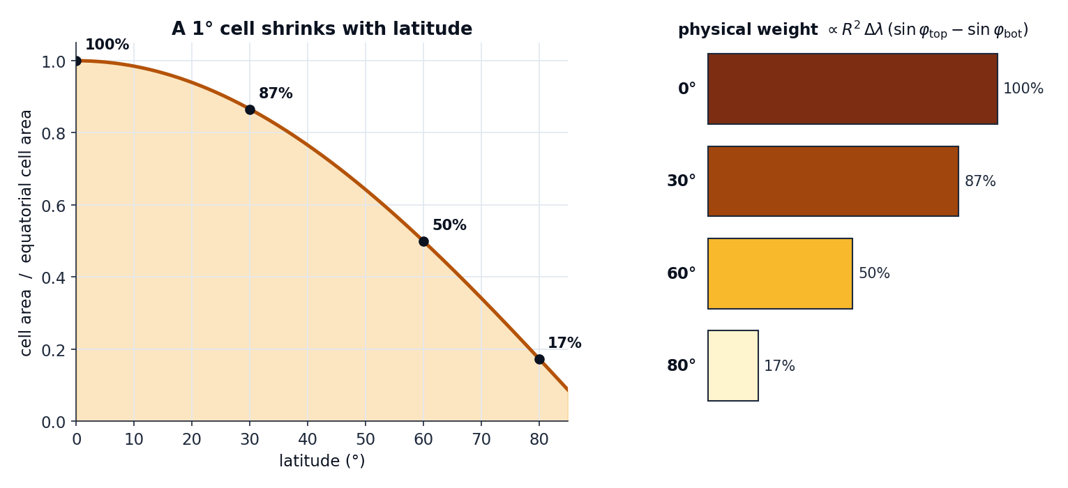
The problem
A 1° × 1° cell spans the same number of degrees everywhere, but as you move toward the poles the meridians converge, so the cell's footprint on the sphere shrinks. A cell at 60° latitude has only about half the area of one at the equator; at 80° it is down to roughly a sixth.
If you treated every cell as equal, high-latitude cells would be over-weighted in the mean — a polygon's average would lean toward whatever its poleward cells happen to say.
The fix
geohalo multiplies each cell's coverage fraction by its true spherical area before row-normalising. The area of the cell between latitude edges \(\varphi_\text{bot}\) and \(\varphi_\text{top}\) and spanning \(\Delta\lambda\) in longitude is the exact integral of the sphere's surface element:
with \(R = 6\,371\,008.8\ \text{m}\) (the mean Earth radius) and angles in radians. The \(\sin\varphi_\text{top} - \sin\varphi_\text{bot}\) term is what bends the curve above: it is the band-area formula for a sphere, exact for the latitude direction.
This is geohalo.geometry.cell_areas:
lat_edges = midpoint_edges(lats)          # N+1 edges from N centres
lon_edges = midpoint_edges(lons)
sin_top = np.sin(np.deg2rad(lat_edges[1:]))
sin_bot = np.sin(np.deg2rad(lat_edges[:-1]))
dlon_rad = np.deg2rad(np.diff(lon_edges))
area_per_lat = (EARTH_RADIUS_M ** 2) * (sin_top - sin_bot)
return area_per_lat[:, None] * dlon_rad[None, :]
Each stencil weight is then coverage × area, so a half-covered equatorial cell
correctly outweighs a half-covered polar cell.
Turning it off
For a planar / equal-area treatment — every cell weight 1.0 — pass
spherical_correction=False:
This makes cell_areas return all-ones and the weights become pure coverage fractions.
It is the right choice when your grid is already on an equal-area projection, or when you
deliberately want unweighted coverage.
Spherical, not ellipsoidal
geohalo uses a spherical Earth, not the WGS84 ellipsoid. The difference in cell area is within ~0.3 %, which is negligible next to the centroid/all-touched bias the coverage choice removes. Ellipsoidal areas are a deliberate non-goal.
Where it folds in
The correction lives entirely inside the stencil build — it is part of
the precompute, so it costs nothing at apply time. The spherical_correction flag is
also mixed into the stencil's cache digest (b"sph" vs
b"flat"), so a spherical stencil and a planar one never collide in the cache.